Quantcast

Technical DOWNHILL places to ride in North Carolina

tvanderkamp

Chimp
Jul 19, 2008
22
0
I've just moved to Charlotte about 2 months ago. Truth is i'm tired of wasting my time climbing fire roads to ride smooth single track back down for four minutes. Where is all the roots, rock gardens, and steeps at?

I don't mind climbing, but it is annoying to climb for an hour on my SX trail, get to the top of something and ride hard packed single track back down. I want to find the steep, gnarly, nasty, technical rides. Any suggestions.....oh, and don't anyone dare suggest Green's Lick. Done it..........not worth the climb up. Smooth..........fast..........worth doing once to hit some big air...but i'm never going back. It was too easy. Passed three guys riding wal-mart bikes who were not having any trouble. I want to find trails that would snap those bikes in half if they tried it.

I've done 26west, and it's fun, but in truth, it is too easy too.

I'm talking about wanting to find something more like A,B,C line up at Snowshoe. I've got full body armor and not worried about getting banged up. I just want to ride some serious downhill.

Again, I don't mind the climbs, but I moved to North Carolina to mountain bike and i'm beginning to think I need to trade in my Five tens for some clip in shoes, spandex shorts, and a hardtail XC bike.

I know there has got to be some big riding out here. There has to be riders with big bikes who are not riding all this epic cross country stuff.

Somebody help me!

Thanks Guys (and gals)
 

AngryMetalsmith

Business is good, thanks for asking
Jun 4, 2006
21,210
10,009
I have no idea where I am
There is some true gnar in Pisgah, which is a huge forrest in different parts of Western NC. You can pick up a map of Pisgah Ranger District (Brevard) at your LBS or hiking stores.

Unfortunately, there is little to be shuttled in Pisgah, you have to climb to get to the goods. BTW, the climb up to Greenslick (the long way) is fairly short for the area.

Trails high on the pucker factor:
Farlow Gap
Bennet Gap (seasonal)
Laurel Mountain to Pilot Rock


Wilson's Creek Area (N of Morganton):
Greentown
Beehive
Headly


Just buy a map and start exploring.
 

tvanderkamp

Chimp
Jul 19, 2008
22
0
I'm totally up for windrock. I've seen some pictures today and watched a few video clips. Do they have people out there shuttling or do you have to make your own arrangements with friends. And how far up is it if you have to pedal? I don't mind an hour of climbing as long as the ride down is worth it.

Thanks for the reply. I feel like i'm getting in a rut here.

What about Paris Mountain? I'm looking at the downhill race coming up. Might enter that when it comes around. What is that like?
Drive 2 hrs to Windrock, TN
 

bizutch

Delicate CUSTOM flower
Dec 11, 2001
15,928
24
Over your shoulder whispering
I'm totally up for windrock. I've seen some pictures today and watched a few video clips. Do they have people out there shuttling or do you have to make your own arrangements with friends. And how far up is it if you have to pedal? I don't mind an hour of climbing as long as the ride down is worth it.

Thanks for the reply. I feel like i'm getting in a rut here.

What about Paris Mountain? I'm looking at the downhill race coming up. Might enter that when it comes around. What is that like?
Windrock.
Talk to the Mueller (Mulestar) about some trails he does private screenings of. :brows:
Get over it. NC isn't Snowshoe. Nothing here is as burly as Snowshoe, except Windrock, which is for the most part burlier, steeper & longer but shuttles are a must.
Pisgah doesn't have any "gnar" shuttles. We all ride plenty of stuff on our DH bikes, but for most all but the Sugar course we cut, they're overkill for the area.

Paris Mtn's DH trail is fun but not something you'd drive down to shuttle, just a section of trail you go down as part of a ride. I called Paris "multiple mini-Greenslick on meth"...fun as snot, but anything over 5 inches of travel on it is boredom.

Climb all the stuff in Brevard behind the horse stables to get your elevation if you come to Asheville.
Get someone to show you Wilson's Creek if you want to shuttle close
Go to Windrock if you want to do just that...rock.
 

tvanderkamp

Chimp
Jul 19, 2008
22
0
I don't mind the climb. I've got the legs and lungs for it. I was just suprised how smooth the trails are here. Like...no rocks, roots or anything in most of the places i've found (so far). And very few steeps really. In fact, the sharpest downhill section I found as far as grade of downhill was just outside of Charlotte off Poplar Tent road. One very short steep. Loved it. Just wish it was 3/4 of a mile long instead of 50ft. Can't help it, I love technical riding!
There is some true gnar in Pisgah, which is a huge forrest in different parts of Western NC. You can pick up a map of Pisgah Ranger District (Brevard) at your LBS or hiking stores.

Unfortunately, there is little to be shuttled in Pisgah, you have to climb to get to the goods. BTW, the climb up to Greenslick (the long way) is fairly short for the area.

Trails high on the pucker factor:
Farlow Gap
Bennet Gap (seasonal)
Laurel Mountain to Pilot Rock


Wilson's Creek Area (N of Morganton):
Greentown
Beehive
Headly


Just buy a map and start exploring.
 

tvanderkamp

Chimp
Jul 19, 2008
22
0
I've got a map of pisgah. Just needed some suggestions on where to go. Someone told me to ride spencer gap and come down Trace Ridge. Did that. But it was very tame. I think there was one section we blasted through that was fun..........couple little water bar drops and rooty sections........one short little rocky section. But that was it. And it was over in like 5 minutes. I'm good with Pisgah. Just need suggestions on where the real tough downhill is. I can handle the climb, but want to be handsomely rewarded for it.

Thanks for the input. I'll check these out. I've gotten some other good suggestions from this as well. I'm looking forward to checking it out.
There is some true gnar in Pisgah, which is a huge forrest in different parts of Western NC. You can pick up a map of Pisgah Ranger District (Brevard) at your LBS or hiking stores.

Unfortunately, there is little to be shuttled in Pisgah, you have to climb to get to the goods. BTW, the climb up to Greenslick (the long way) is fairly short for the area.

Trails high on the pucker factor:
Farlow Gap
Bennet Gap (seasonal)
Laurel Mountain to Pilot Rock


Wilson's Creek Area (N of Morganton):
Greentown
Beehive
Headly


Just buy a map and start exploring.
 

profro

Turbo Monkey
Feb 25, 2002
5,617
314
Walden Ridge
You can climb to the top of Windrock. But I reckon you will do it once. I think it takes about 2 hrs to climb to the tippy top and about 15 minutes to descend.

Here is a elevation profile of a 22 mile we did in Windrock a couple months back and is this tech enough?


Some of the above trail is darn near impossible to stay on the bike.

There are shuttles, but you better line that up before you get here.
 
Last edited:

tvanderkamp

Chimp
Jul 19, 2008
22
0
That is exactly what i want to ride! EXACTLY! Thanks for the info. I've met a few guys here in Charlotte with big bikes. Hopefully I can talk a couple of them into going out there soon. Doesn't look like something to pedal. Get a couple cars and it will be on!

Thanks again!
You can climb to the top of Windrock. But I reckon you will do it once. I think it takes about 2 hrs to climb to the tippy top and about 15 minutes to descend.

Here is a elevation profile of a 22 mile we did in Windrock a couple months back and is this tech enough?


Some of the above trail is darn near impossible to stay on the bike.

There are shuttles, but you better line that up before you get here.
 
Yeah mad props to NC but the reality is that any rider can drive to windrock and have access to sweet and nasty tech DH all day long with ease.

With the opening of the Walden ridge bike trail 5 minutes away from windrock i don't see how the guy can go wrong here.
Just post up when your coming.

:pirate2:
 

JohnBoy

Monkey
Jan 15, 2007
385
0
Has anyone ever actually made it down SMP? I was once told that if anyone ever asked me to ride SMP to swear at them and run the other direction. :D
The very top section has never been cleaned. If you think you can, you will have to go with one of the crazy fVckers that will even think about trying it. Cause I will not waste my time going, even to watch a really good wreck, cause you will wreck, promise ya.
 

bizutch

Delicate CUSTOM flower
Dec 11, 2001
15,928
24
Over your shoulder whispering
The very top section has never been cleaned. If you think you can, you will have to go with one of the crazy fVckers that will even think about trying it. Cause I will not waste my time going, even to watch a really good wreck, cause you will wreck, promise ya.
I read a post on the Hick Hucksters about that thing. I wanna see it. Not saying I will ride it...but me, Jeremy and others have done things that sometimes others can't. Too, being older, I'm good at talking groms into stuff too:crazy::crazy:

FYI on the Trace Ridge thing. It's a road. You are supposed to climb up Spencer Gap, CROSS Trace Ridge & go down Spencer Branch halfway & turn rt on the gravel road, then go left on Fletcher Creek. Much longer ride, more fun. Everybody but me hates Spencer Branch b/c it's "rockish".

Oh...and if you're the man to ride steeps, get someone to show you how to drop down from Pisgah Mtn to Big Creek...just walk your bike on Parkway property. :thumb:
 

JohnBoy

Monkey
Jan 15, 2007
385
0
Bizutch, I know you and Jeremy are both very capable riders, the fact is, is that the sh!t is too steep and too rooty + the fact that there is a 90 deg. turn at the bottom of that first section that if you dont wreck beforehand, you wont be able to stop and you will go off the ledge :shocked:. Its just really not worth the trip to watch people look at it and go "aint no way Im trying that sh!t", and then you have to carry your damn bike, I should say lower your bike section by section to get to anything you can try to ride. You saw Neckers video I believe, Necker takes the teck out of tecky riding, the kid can ride anything and you saw what happened to him, he almost broke his neck.
 

MTB_Rob_NC

What do I have to do to get you in this car TODAY?
Nov 15, 2002
3,428
0
Charlotte, NC
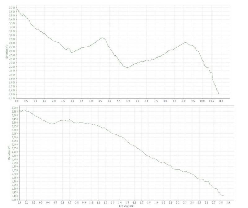
Here is a typical (in whole or parts of) Saturday ride from the "regulars" out at Wilson's Creek


Raspberry - Greentown - Beehive
http://trail.motionbased.com/trail/activity/6239041
Summary Data
Total Time (h:m:s) 2:43:58 15:00 pace
Moving Time (h:m:s) 1:33:12 8:31 pace
Distance (mi ) 10.92
Moving Speed (mph) 7.0 avg. 35.1 max.
Elevation Gain (ft) +1,454 / -3,610

Headley from the top
http://trail.motionbased.com/trail/activity/6239040
Summary Data
Total Time (h:m:s) 0:19:59 7:01 pace
Moving Time (h:m:s) 0:14:55 5:15 pace
Distance (mi ) 2.84
Moving Speed (mph) 11.4 avg. 33.1 max. (I have gone as fast as 39 on this trail, following Necker I believe one day.
Elevation Gain (ft) +167 / -1,323

Here are the elevation profiles of the two rides..

Raspberry - Greentown - Beehive on top, then Headly from the top


Raiders is great
I still havent done Sinkhole
No Name to Letter Rock to Steele's is "OK" but much like the comments on SMP there is more Hike a Bike then what I enjoy.
 

tvanderkamp

Chimp
Jul 19, 2008
22
0
I think I want to go see SMP too. I've managed to creep and bounce my bike down a lot of rooty rocky stuff that looks unridable (too silly not to try it I guess) and still make a tight switchback. But, i've never seen this place so it might be too much. There are things that are unridable.

I might go back to Trace Ridge again and try the way you suggest here. The guy at CarolinaFatz told me there was really gnarly tech riding up there, but I must have gone the wrong way and not found it. I rode up the fireroad, turned left at the boundary gate, climbed up a really steep hill, hit the top, climbed up some more not so steep hills, and then hit the downhill that lead back to the parking lot by the creek crossing about halfway up the mountain. I did not see any trail markers going below the parking lot so I thought that was it.

I'm definitely going to try windrock soon. I've got a friend of mine that I ride with from Florida coming up next month. We were planning on doing our annual Snowshoe Run, but maybe we'll hit Windrock instead and then I'll go up to Snowshoe in a couple weeks. Windrock is a lot closer than Snowshoe from Charlotte.

Thanks for all the suggestions. I know there is going to be awesome riding out here. I just got to get with people who know there way around. The bike shops here in Charlotte don't seem to know much outside ot Catawba and Bent Creek as far as riding locations.

Thanks again!
I read a post on the Hick Hucksters about that thing. I wanna see it. Not saying I will ride it...but me, Jeremy and others have done things that sometimes others can't. Too, being older, I'm good at talking groms into stuff too:crazy::crazy:

FYI on the Trace Ridge thing. It's a road. You are supposed to climb up Spencer Gap, CROSS Trace Ridge & go down Spencer Branch halfway & turn rt on the gravel road, then go left on Fletcher Creek. Much longer ride, more fun. Everybody but me hates Spencer Branch b/c it's "rockish".

Oh...and if you're the man to ride steeps, get someone to show you how to drop down from Pisgah Mtn to Big Creek...just walk your bike on Parkway property. :thumb:
 

JeffKill

Monkey
Jun 21, 2006
688
0
Charlotte, NC
I think I want to go see SMP too. I've managed to creep and bounce my bike down a lot of rooty rocky stuff that looks unridable (too silly not to try it I guess) and still make a tight switchback.
I will bet my life that nobody can clean that line, its not even a trail. I've seen a couple people get hurt pretty good on it, and they were MORE than capable riders. And its not a switchback at the bottom of the first part, its a 90 degree turn, or plow into trees. And I assure you that IF you make it that far, you wont make the turn and you WILL hit the trees.

Bottom line is, the few people that have tried it probably shouldnt have. The last thing we need someone getting seriously hurt up there trying to prove something, bringing unwanted attention to the area.
 

drkenan

anti-dentite
Oct 1, 2006
3,441
1
west asheville
So it looks like Beehive drops ~1000ft over ~2 miles? It's hard to read that graph but that's not too shabby! That's gotta be the best trail at Wilson's. Someone needs to show that to the OP.
 

bizutch

Delicate CUSTOM flower
Dec 11, 2001
15,928
24
Over your shoulder whispering
Somebody post the link the necker's vid. I haven't seen it.

TVK..your new moniker...nothing in Mills River is
really gnarly tech riding
.
Basicly as soon as you come onto Trace Ridge, you go straight across the ridge to hit Spencer Branch. But compared to Trace itself, it's 100 times more tech. Spencer Branch meanders across some big open fields, pops into some woods 7 just picks up more & more speed & spits you out at the reservoir.

I'd probably skip loops in the Trace Ridge section if you're driving from that far away. You can ride much longer loops with more tech descents if you knock out 15 minutes more drive time & ride around the horse stables or fish hatchery in Brevard.

Also, you mentioned Star Gap/Heartbreak/Kitsuma. Keep in mind there are about 3 different variations to that ride to get completely different descents. One fun variation is to go up Star Gap (merciless) then left on Heartbreak & descend the Old Toll Road (forever long) then left down Rattlesnake to the water tower inside Ridgecrest then out of the parking lot & across the street to finish on Kitsuma.
 

MTB_Rob_NC

What do I have to do to get you in this car TODAY?
Nov 15, 2002
3,428
0
Charlotte, NC
So it looks like Beehive drops ~1000ft over ~2 miles? It's hard to read that graph but that's not too shabby! That's gotta be the best trail at Wilson's. Someone needs to show that to the OP.
Drops ~1300 in under 2 miles. Jeff/John and I pinned it one day without stopping and descended it in ~9 minutes.

If you do not like Beehive you might be Ghey:pirate2:
 

bizutch

Delicate CUSTOM flower
Dec 11, 2001
15,928
24
Over your shoulder whispering
I will bet my life that nobody can clean that line, its not even a trail..
That guy Tyler that rode with us the day you showed us the trails...he is not human. He has ridden things that Herndon would just say "Nope. That's stupid." It's a shame he doesn't ride anymore or we'd have to show it to him....:lighten: Not saying he could ride it...but if I'd put my life on the line to ride something, I'd pick him.
 

MTB_Rob_NC

What do I have to do to get you in this car TODAY?
Nov 15, 2002
3,428
0
Charlotte, NC
Somebody post the link the necker's vid. I haven't seen it.

TVK..your new moniker...nothing in Mills River is .
Basicly as soon as you come onto Trace Ridge, you go straight across the ridge to hit Spencer Branch..
WHen you are riding the trail, keep an eye out on the RIGHT for the intersection with Spencer. Although Bizutch is correct in saying stay straight, the more worn (Trace) trail veers to the left so Spencer is off to the right.
 

tvanderkamp

Chimp
Jul 19, 2008
22
0
You know, I saw that video about a month ago. Is that SMP?

Now granted, I know video shrinks everything by about 3x, but I remember watching this thinking that it didn't look that bad and I couldn't figure out why he crashed? I'm also not sure if the vid was shot in slow motion, but i'll have to check it out. Looks to me like if you creep it, pick a good line, and put your rear on the back tire, it wouldn't be too bad. I've seen a lot worse..........but, I ackknowedge again that video makes everyting 3x smaller. I hate that when we have shot freeride footage of stuff that hardly anyone would ride and then check out the video and people go.....well that doesn't look so tough LOL!
 

wiL

Monkey
Nov 28, 2006
186
0
Greenville, SC
If necker can't do it, then no one else should really waste their time even going up there other then sh!ts and giggles. my 2 cents.

Moving on- tvandercamp, check www.bikepasa.com if you haven't already for group rides from charlotte to wilson's creek.

Most places in the region are a lot easier to just be shown than to follow some map, so my suggestion is just to get socially connected in the riding scene and the gnar shall be bequeathed upon you with overwhelming abundance.

props to windrock.
 

tvanderkamp

Chimp
Jul 19, 2008
22
0
Yes! Quest Complete! I met up with Basher, Jondog, and about 15 other guys and headed out to Wilson's creek. We hit Rasberry,Beehive, sinkhold, and Goat and another mid-section I forget the name of. It was a rocking good time. A couple sections of Beehive were like doing a handstand on the bars. Loads of fun! Thanks for the introduction to everyone. I moved to North Carolina just to ride that kind of terrain. My SX trail is perfect for that kidn of riding and climbing and everyone I met was super nice. Great group of guys. They let me know where to let 'er rip and where to check up and not fly off the side of the mountain. Good stuff. I can't wait to get out there again. And again..........well..........and pretty much every chance I get until i'm too old and crippled up to pedal! Again, Rockin good time! Thanks so much!
So was any really gnarly tech riding found this weekend?
 

AngryMetalsmith

Business is good, thanks for asking
Jun 4, 2006
21,210
10,009
I have no idea where I am
Yes! Quest Complete! I met up with Basher, Jondog, and about 15 other guys and headed out to Wilson's creek. We hit Rasberry,Beehive, sinkhold, and Goat and another mid-section I forget the name of. It was a rocking good time. A couple sections of Beehive were like doing a handstand on the bars. Loads of fun! Thanks for the introduction to everyone. I moved to North Carolina just to ride that kind of terrain. My SX trail is perfect for that kidn of riding and climbing and everyone I met was super nice. Great group of guys. They let me know where to let 'er rip and where to check up and not fly off the side of the mountain. Good stuff. I can't wait to get out there again. And again..........well..........and pretty much every chance I get until i'm too old and crippled up to pedal! Again, Rockin good time! Thanks so much!
Cool man, glad you got yer fix.

If you liked Beehive, you'll have a hard on for Bennett Gap. It opens October 15th.

In the mean time take a stab at Farlow Gap. The upper section is World Cup style DH with a long steep rock garden that turns to the right. There is a lot of pushing and some hike a bike after that.
 

bizutch

Delicate CUSTOM flower
Dec 11, 2001
15,928
24
Over your shoulder whispering
Cool man, glad you got yer fix.

If you liked Beehive, you'll have a hard on for Bennett Gap. It opens October 15th.

In the mean time take a stab at Farlow Gap. The upper section is World Cup style DH with a long steep rock garden that turns to the right. There is a lot of pushing and some hike a bike after that.
Disclaimer:

Farlow may in some instances cause cramping of the ankles. While rare, ankle cramping may be severe & often followed by sudden & rapid weight gain. Consult your physician regarding ankle cramps to determine if Farlow is right for you. This message brought to you by the Council on John Doe is a Limp Ankled Fairy.
 
Last edited by a moderator:

JohnBoy

Monkey
Jan 15, 2007
385
0
It is a SECRET / HIDDEN trail, you will not find it unless you are shown, and NO ONE, if you do know, needs to be putting up info on a public forum.
 
Last edited: